
Isn’t taxiing supposed to be one of the “easy parts” of being a pilot? At first glance, it might appear that taxiing an aircraft is much, much easier than flying it. A non-pilot might think, “There are really easy-to-read signs, just like on streets, right? You turn left, turn right, stop. Just like a car, right? Otherwise taxiing an airplane would be totally dangerous and difficult, right?”
Turns out, yeah, there are signs, and turns and stopping are all part of the skills. But a few things are overlooked in this analysis. For one, the machine we’re steering on the ground likely has only three small wheels, two smaller brakes, merely uses one wheel to steer and there’s no reverse. There’s a very specific route you have to follow, and there are lots of similarly ill-handling machines nearby trying to do the same thing. The icing on the cake, of course, is ATC.
Over-Caffeinated ATC?
For example, the tower people like to call you as soon as possible after you land, four seconds after the wheels hit the ground (or after the mains hit the ground for the first time, in one of my landings): “Citation 12345, where are you parking?” is just a super call to get at about 83 knots groundspeed, the reverser buckets still out and engines howling.
I got this gem of a taxi instruction from a chipper tower controller the other day: “Citation 12345, turn left on Runway 13, right on Alpha, left on Echo, right on Echo Two to parking with me.” We were the only aircraft moving at the airport. In the cockpit, on rollout, the call sounded like: “Citation12345turnleftonRunway31rightonAlphaleftonEchorightonEchoTwotoparkwithme.” He spoke at 18 knots, gusting to 30, when the crew’s demonstrated bandwidth was 23 knots.
Now, to be fair, he may be a part-time auctioneer, or maybe there was a squadron of airplanes coming in, unknown to us and on other frequencies, and he wanted us off the runway. Or maybe he was over-caffeinated. Anyhoo, his radio call tripped all three circuit breakers in my head. I said to the pilot next to me, “Dang, I didn’t get that, did you?” He turned and looked out the window, then at the floor, and then tapped on a gauge, pretending to be busy. (I deduced from his actions he had gone November Charlie—no clue. This is real-world CRM, folks.) Thinking quickly, I realized I had to query the tower dude. To sound good, I keyed the mic and said professionally, “Huh?”
The tower guy said it all again, just as fast, and this time I got it, reading it back correctly. Then the tower guy laughed. It that sounded a lot like, “Ha, ha, yeah, it’s just jump to the left—and then a step to the right, ha, ha!”
The next time we landed there, the tower guy spoke more slowly and more clearly—the coffee pot might have been Tango Uniform. Still, I dorked up the read back that time, too, even though I knew exactly what he said. Sigh.
Betting In The Office Pool
Understanding a rapid-fire taxi clearance at an unfamiliar airport is one challenge of taxiing. (What’s that you say, dear reader? Oh, why thank you—I didn’t even think of pre-studying the airport diagram, and having it open on my iPad eight inches from my face.) But have you ever noticed how there sometimes aren’t really excellent sign locations at an airport? How sometimes, the taxiway signs are so far apart that after you pass one sign and turn a corner, the next one telling you that you are on the correct taxiway is so far ahead you can’t see it without taxiing a long way? You’re given taxi instructions, and then the ground frequency goes dead quiet, and they watch you from the tower to see if you figure it out, making side bets.
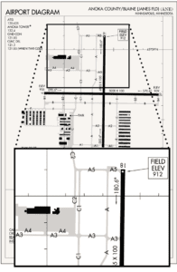
Take Anoka County/Blaine (Janes Fld) (KANE)—where do they get these names, anyway?—known secretly to me as “this infernal airport.” The FBO, Atlantic Aviation, is on the north side of the field, at Taxiway C2, right next to C1, and then you have your A3, not to be confused with A4, parallel right next to it, and down (or up) in the corner, lurking, is Taxiway A. The airport diagram and inset at left shows the arrangement. We pilots can follow taxi instructions, but, in the case of KANE, it’s super easy to make a wrong turn, my instructor said, and pilots do it all the time.
Sometimes a taxiway sign will be located before the taxiway (you turn after the sign), sometimes abeam it (turn at the sign) and sometimes after it (turn before the sign). Worse is the hold short line for Runway 26 at the Eastern WV Regional Airport/Shepherd Field, KMRB. (What, do the people who name airports just speak names until they run out of breath?) You’re supposed to hold short before coming anywhere near turning perpendicular toward the runway, like, let’s see, every other airport you’ve ever been at, ever.
Did I mention that the miserable hold short line for Runway 26 is faded and almost invisible? It is—or was the last time I was there—but why? Obviously, because there is no more paint left in the world. So the tower controllers at KMRB just wait, watching you with their binoculars until you (“I”) taxi across the hold short line without clearance, and then snort over the radio: “You just crossed the hold line for Runway 26. Snort.” Then they high-five each other and check to see who won the office pool. But Martinsburg tower doesn’t hammer you—violate you—they had their fun with your (my) hold-line crossing and are busy betting on the next pilot to cross the faded-out paint stripes without clearance.
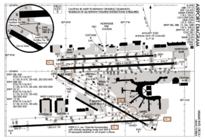
Or take KMIA. Please. At Miami International, where Taxiway Q meets Taxiway M, there is a strange triangle shape with dashed lines around it on the airport diagram. Naturally, it’s a hot spot, involving approximately 150 taxiways. The airport diagram and inset at left highlight the mishmash: Taxiways R1, Q1, Q, N, M, M1, L1, for heaven’s sake, and then you have your Runway 12 and 8R barging in, too, demanding equal attention. It’s an aggregation—a “gob,” a “goat rope,” a “dog’s breakfast”, even—of taxiways and runways, all meeting together in the same place. A riddle, wrapped in an airport diagram inside a violation, waiting to happen.
In June, the FAA announced it is allocating $6 million to clean up that little Bermuda Triangle at KMIA. The investment is part of a 12-airport, $100 million-plus project to reconfigure taxiways that may cause confusion, install airfield lighting or construct new taxiways. “Some airfields have complex layouts that can create confusion for pilots and other airport users. This funding will reconfigure complex taxiway and runway intersections to help prevent incursions and enhance the safety of the National Airspace System,” FAA Associate Administrator Shannetta R. Griffin, P.E., said when the KMIA and other projects were announced. Officially, the money will be used at KMIA “to shift one taxiway (L1) and fix the intersection of two other taxiways (M & Q).” Many pilots have disappeared there over the years, turning up at a Walmart parking lot in—you guessed it—Anoka County.
Problematic Geometry
This isn’t a new problem. A 2018 report from the FAA’s William J. Hughes Technical Center, Problematic Taxiway Geometry Study Overview, identified 6098 airport locations with non-standard, “problematic” geometry. The study listed 19 different things that lead to pilot confusion. I plucked out four from their list:
Non-standard markings and/or signage placement;
Use of a runway as a taxiway;
Unexpected holding position marking on parallel/entrance taxiway; and
Greater than three-path taxiway intersection.
There’s a lot of material, with overhead photographs, all which presumably is used when planning hot spot designations and remedial infrastructure projects.
If taxiing was easy, would there even be hot spots? You look at some airports and think: “Why not just put a hot spot circle around the whole thing?”
As things stand, a person sitting at home could look at an airport diagram and think, “How could someone ever dork up taxiing from parking to the runway, or from a runway to parking? It looks simple.” Yeah, from your chair at home. But from three feet above the taxiway, it all looks different. And the same.
Obviously…
We pilots, even though it’s the year 2023 and we have iPads, have to do more than get a taxi clearance, jot down some shorthand notes, glance at the airport layout, push up the throttles and start taxiing, and assume the taxiway signs and markings will be obvious—oh, it’ll all be obvious, no prob.
Everything is obvious—until it ain’t—and then a pilot can suddenly find themselves smack dab in the middle of a big patch of concrete with no signs and no markings and you’re supposed to know which way to go. Because you did copy down the taxi clearance, right? Yes, yes, of course. But still…where the heck is Taxiway E2?
My oh-so-patient instructor at KANE recently told me to really think—visualize the different possible taxi routes the controller might give me, when there is time to think—like before starting descent into the airport, or before calling for taxi clearance from parking.
In my case, I’ve realized that if I don’t really pay attention, I can get turned around even at a super-simple airport with simple taxiways. Sigh. I wish taxiing was as easy as flying an ILS down to minimums in a crosswind at night—which, of course, the autopilot does for me.
Matt Johnson is a former U.S. Air Force T-38 instructor pilot and KC-135Q copilot. He’s now a Minnesota-based flight instructor.


Given the rapid fire taxi clearance, how about replying “Citation 12345, student pilot, request progressive”?