
188
My experience took place in July 2007. It involved me and some friends on a long VFR cross-country flight from Leonardstown, Md., to Vero Beach, Fla., in my Piper Archer.
On our final leg, we encountered an area of thunderstorms in our path that was moving westward. Thus, we deviated eastward just off St. Augustine to avoid the worst weather. We were getting weather reports from Flight Watch and flight following. (As it turned out, the ATC facility providing flight following services contradicted Flight Watch, but ATC was right.)
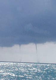
Ahead of us, from about 3500 feet to 1500, was a long, cylindrical white cloud (dark on the bottom). We requested a descent so as not to go into it. As we neared the bottom and were about 20 seconds from passing underneath, I noticed that the ocean underneath the cloud was stirred up in several areas. It turned out to be the early stages of a water spout!
To the east, several others were already descending from this cloud. We immediately did a 180-degree turn, breaking into St. Augustine’s airspace. That was the least of our worries as we told the tower we needed to get on the ground to kiss the pavement.
I later learned that these clouds sometimes extend out of the back side of thunderstorms, consisting of a horizontal vortex out of which vertical ones emerge toward the ground. It was definitely something I had never expected, because we weren’t near any storms that we could see, but we were behind the line of storms. Thank God we were VFR and weren’t vectored into that mother.
What did I learn? Pay close attention to convective activity and never try to go under a storm cloud.
— Dan Corrigan


