Flying is great when everything is working; we train for when things break. One thing that has made flying easier and more fun is RNAV systems, primarily the global positioning system (GPS). While pilots study the navigation displays in the airplane, and train for when (not if) they will fail, the FAA and other regulatory agencies have to think about the whole system. Losing your navigator would be one big suck, but what if there’s no GPS signal for the panel-mounted or even a handheld navigator to process?
If GPS were the sole means of navigation and it failed suddenly, the FAA would have a lot of aircraft wandering around with no way to use their RNAV capabilities, or maybe even shoot an approach to their destination. So at least until some other accurate navigation system with global coverage is put into widespread use, they have to keep some VORs and ILSes around. It’s prudent, and FAA expects the VOR/ILS system to be the primary backup in emergency outages. Of course, the system is still approved as a sole means navigation, all the way down to 200 feet agl, and lower. The result is the minimum operational network, MON, a selection of VOR and localizer/glideslope facilities that will remain operating for the foreseeable future.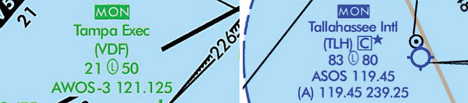
MON
Of course, the FAA doesn’t like VORs. They’re expensive to maintain or replace, and don’t offer the convenience or accuracy of GPS navigation. (DME-DME navigation, with the right flight management system, can be quite accurate, but does not have much future. Some RNAV approach procedures allow DME-DME navigation; some do not.)
First, the FAA is extending the service volume of low-altitude VORs to 70 nm, so there will be VOR coverage everywhere above 5000 feet msl, at least in non-mountainous terrain.
The next part is figuring out which airports have VOR or localizer approaches that don’t require DME. The FAA has done that for us, and identified these airports with the text “MON” above the airport name on its low-altitude IFR en route charts. Two examples of this symbology are reproduced on the opposite page.
These airports meet a lot of requirements. Besides having a VOR or LOC approach, perhaps with a glideslope, the approaches, including at least one missed approach, cannot require DME. These airports are also named in the Chart Supplement, but they are not identified on sectional charts. It’s presumed, I guess, that VFR pilots can use pilotage or the VORs when GPS goes down.
Finding the airport means that you have to have an idea where you are, but many moving map displays depend on GPS, and won’t work. People make fun of me (you can, too, if you wish), but this is why for anything but a local flight I carry a paper navigation log and write down the time when I pass the fixes. Then I have an idea where to look on the chart.
Once you’ve identified an airport, plan on flying a procedure turn or charted route from the en route structure to someplace where you can start the approach. This may be pretty inconvenient. The airport where I fly is a MON airport, but the entries to its localizer approach are a VOR about 18 miles north and another about 10 miles west.
If you are approaching from the southeast, you can fly well north of the airport before turning inbound, or intercept a radial that crosses the localizer at a 90-degree angle, do a procedure turn and fly 18 miles to the runway. If you miss the approach, the holding fix is almost 20 miles away.
The minimum descent altitude for this approach is 800 feet agl or 400 feet, depending on how you’re equipped: You need two VOR receivers to use the lower MDA, and I’ve seen a lot of airplanes with only one. You also have to plan to miss. The whole process may take 30 minutes longer than “direct,” which can mean a lot of fuel.
Without DME, you need to time the legs of the procedure turn, any hold and the final approach segment of a non-precision approach (unless the missed approach point is a VOR). Nowadays, the panel clock with a sweep second hand (or its digital equivalent) can be a little difficult to find.
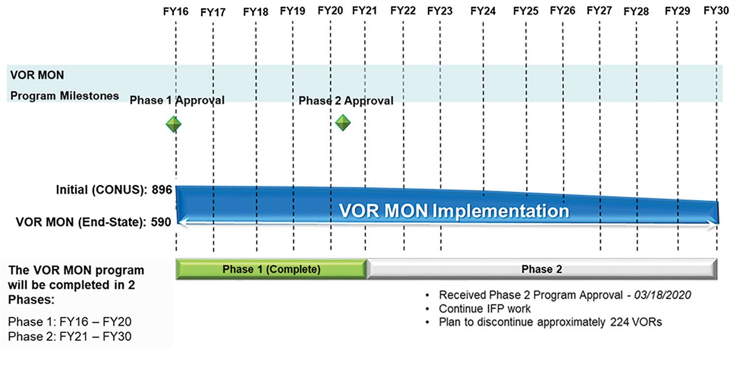 The timeline above details the FAA’s 15-year schedule to implement its MON program, which began in FY 2016. As the infographic details, there were almost 900 VOR facilities at the program’s start, with the plan for 590 of them remaining operational at the program’s conclusion in FY 2030. Some 306 VORs—one-third of the starting number—will be decommissioned. Some highlights, adapted from the Aeronautical Information Manual (AIM):
Global Navigation Satellite System (GNSS) Disruption
The MON will enable aircraft to navigate through the affected area or to a safe landing at a MON airport without reliance on GNSS. The MON will provide nearly continuous VOR signal coverage at 5000 feet agl across the NAS, outside of the Western U.S. Mountainous Area (WUSMA), where there are no plans to change the facility or route structure.
Distance to a MON airport
The MON program will ensure that an airport equipped with legacy ILS or VOR approaches will be within 100 nm. Facilities supporting these approaches will be retained.
Using the VOR MON
An unscheduled GPS outage is likely to be disruptive, causing high workload and demand for ATC services. Generally, the VOR MON concept will enable pilots to navigate through the GPS outage or land at a MON airport, or at another airport that may have an appropriate approach or may be in visual conditions.
Flight Planning
The FAA has not mandated that flight planning include provisions for aircraft to carry sufficient fuel to proceed to a MON airport in case of an unforeseen GPS outage: Listing a MON airport as a filed alternate will not be required.
— J.B.
VOR Navigation
It may take a little effort to recall what “VOR” means: Very-High Frequency (VHF) Omni-Directional Range. Of course, VHF is the frequency band, which like communications, depend on line-of-sight. “Omni-Directional Range” is a leftover from the old ground-based facilities that only offered a handful of courses—VORs offer 360 course directions, unless something like a mountain gets in the way. If you’re a relatively new pilot, or still in training, and have never used a VOR, congratulations. But you should become familiar with the technology, perhaps with your flight instructor along for the ride.
One aspect of VOR navigation that many of us forget is the need to perform a routine check of the equipment at least every 30 days if it’s to be used under IFR. See FAR 91-171 for the details. Note that a ground-based VOR test facility (VOT) offers the most accuracy for these checks, but airborne testing also is permissible. Airplanes with dual VOR receivers can be checked against each other. The checks must be recorded. Note also that the VOT offers only one course, and that the VOR head’s To/From flag must indicate you are north of the facility. (“Cessna doesn’t make a 180 From; it makes a 182.”) The Chart Supplement has details on VOT facilities and checkpoints where airborne tests may be conducted.
What You Need Now
If you have been getting regular instrument proficiency checks, then you have practiced navigating by LOC/VOR alone, but you can still be instrument current if you have done a hold and the same RNAV approach six times within the last six months with no VOR interaction at all. (I admit that it took me a minute to remember how to interpret the VOR course deviation indicator.) In other words, you need to practice, at a minimum through some chair-flying. Think about how to intercept a given course, and how to identify cross fixes en route and during approaches.
While you’re out shooting RNAV approaches, work in an ILS, a localizer or a VOR-only procedure. The day may come when you’re glad you did.
Conclusion
While most of us don’t operate outside the U.S., those who do increasingly see GNSS disruptions. According to online sister publication AVweb.com in January, “For the last six months, airline and other civilian pilots have reported incorrect data corrupting or crashing their navigation systems.” The problems started in the Middle East, and also have been reported in eastern Europe and over the Arctic.
Remember that the purpose of the MON is to get airplanes safely on the ground in a desperate situation. Getting to your destination may require a little luck: Is it a MON airport? Is the weather above minimums? But you should be able to land somewhere.
 It’s tempting to think that a failure of the GPS system would require total destruction of the universe or an act of war, but nature alone can cause problems in the form of a solar storm. My explanation for what could happen parallels the idea that it’s difficult to receive distant AM broadcast stations during the day: solar energy overwhelms the relatively weak signals. For GPS, a solar storm could overwhelm the relatively weak GPS signal in a similar way.
Meanwhile, acts of war are being blamed for GPS signal disruption—jamming and spoofing—overseas. Yet, according to the GPSWorld magazine and website, “Most GPS interference is unintentional. A two-year European Union study found hundreds of thousands of potentially harmful signals, but judged only about ten percent to be intentional. The rest were the inadvertent byproduct of poorly tuned electrical and electronic equipment.”
The magazine added, “In two separate incidents [in 2022] strong interference near the Denver and Dallas airports impacted air traffic, each for more than a day. The Denver incident lasted for 33 hours before authorities found the source and shut it down. Air traffic was disrupted at Dallas for 44 hours according to government sources, though researchers found the actual interference only lasted for 24 hours. The source of the disruption was never identified.”


Very timely article considering Mr. Putin has threatened to launch a nuclear device into space which if used I am sure would render the entire GNSS kaput! Practice those VORs!!