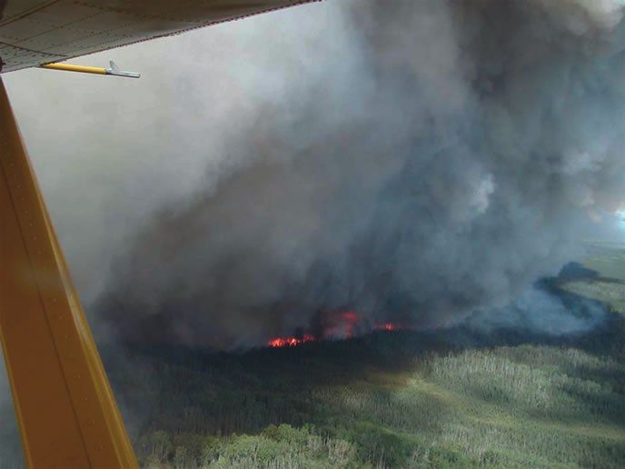
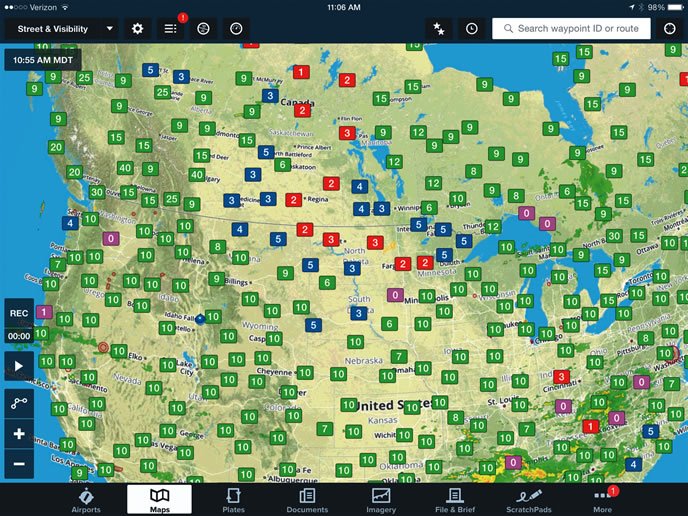
The blue of a dry western sky can be breathtaking. But just after winter’s overcast gives way to clear and deep blue, an insidious menace begins to turn the blue skies white: smoke from the summer fire season. If the national news is covering numerous large western fires, anybody planning a flight in the western U.S. between July and October needs to be prepared to factor smoke into their pre-flight briefings. Check the fire map, or at least glance at the distribution of forest-fire TFRs.
While it’s hard to find NTSB reports singling out smoke outside the cockpit as a significant safety factor, my experience seeing the outflow from major fires turn perfectly good VFR flying weather into IMC says otherwise. Sometimes it is a regional phenomena. Other times it is quite localized. No matter what, it always has an impact on my aeronautical decision-making.
Regional Impacts
The forecast for the entire weekend was clear skies with no clouds in sight. Perfect weather for a long cross-country right? A company had agreed to reimburse a flight from Idaho Falls to Denver in a personal aircraft at the GSA mileage rate for personal aircraft. Winning! There was just one problem, it was IMC weather and I wasn’t IFR current. Reported visibility was 1-3SM HZ FU. For those of you who temporarily misplaced your Metar decoder ring, that translates into one to three statute miles in haze and smoke.
A clear sky and IMC? How can that be? Easy: There were big fires in California. For the entire week, the forecast visibility was between 1-3 miles along the entire route across Utah, Wyoming, Idaho and Colorado. Since I was not IFR current, the trip was scrubbed. That was the last time I let my IFR currency go stale.
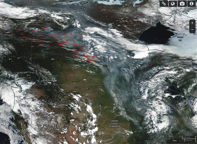
As a cause for IMC weather, smoke is often an overlooked factor. In a bad fire year, visibility across the western U.S. often can plummet from the usual 100-plus miles to a paltry three or fewer. And it isn’t just the West that can be affected, as satellite-based imagery like the one reproduced on page 18 attests. Smoke from fires in Northern Canada in July of 2015 resulted in low visibilities and IFR conditions deep into the Midwest U.S.
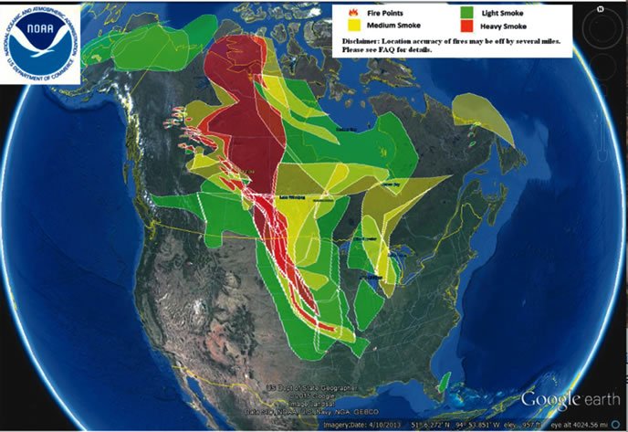
Unfortunately and unlike more traditional weather patterns, most aviation weather tools neglect to factor smoke into the graphical displays. To find it, you have to dig into NOAA air quality aerosol models or keep your eye on fire-related TFRs.
From a risk management standpoint, smoke creates a lot of novel hazards, chiefly a loss of visibility and subsequent disorientation. Basically, whenever there is reduced visibility, smoke exacerbates the problem. There are other hazards, of course, and they may be ones you don’t expect at first: turbulence, coughing, quick loss of visibility, heat, downdrafts, etc.
Reduced Visibility
Oddly, the people most likely to get disoriented by smoke are western pilots; we’re used to nearly unlimited visibility. Perhaps without even realizing it, we use landmarks like distant mountain ranges to help orient to the cardinal directions. We may seem like we have a good sense of direction, but what we really have is familiarity with the orientation of the mountain ranges in our backyard. When the sky turns white and the mountains become obscured by smoke, that homing instinct is gone.
Midwestern and eastern pilots are more used to reduced visibility. In the haze and humidity of the Midwest U.S., visibility is commonly below five miles and often hovering at three. For me, though, when visibility drops below 10 sm and I can’t see familiar mountain ranges, it feels like IMC. My crutch is gone. One steep turn and I have no idea which way I am going.
Night VMC that feels like IMC
In fact, one of the hardest IMC conditions I ever faced was a VMC flight. I had agreed to ferry a friend to pick up her newly purchased plane. My plan was to fly her along with her instructor from Hamilton, Mon., to Provo, Utah, to pick up a Piper Tri-Pacer she bought for training.
To get to the destination early, I launched before dawn. I was night current and the weather was clear with some high clouds, no moon, and the typical smoke from summer forest and wild fires. At 0500 local time, I hopped into the plane and headed northwest across the barren Idaho/Montana border following Victor airways. After crossing the Interstate highway near Dillon, Mon., I ventured into what felt like no-man’s land. The five-mile visibility wasn’t just a default report; it was the actual visibility. Both the horizon and stars were obscured by thick smoke. It was a struggle to keep the plane on a steady heading and altitude. I looked up the MEA and climbed, but still struggled with my heading.
That was when it dawned on me I was effectively in IMC. I quickly snapped into instrument scan mode and my course stopped looking like a seismograph. At last, I locked my heading and altitude down to PTS standards. It was tough IMC flying, yet I had better than the minimum visibility required for VFR.
When sunrise came, visibility was still very much the same. I could see the ground beneath the plane, but not as far ahead as I am used to while flying in the mountains. And the horizon blended with the mountains. I could make out very little of what was in front of me through the smoke. I stayed above MEAs and kept up my instrument scan until I had the airport in sight. From that trip onward, I never underestimated the power of smoke to kick my butt.
Canyon Inversions
I took a friend and author into the wilderness to support research on her book. The Sun Valley, Idaho, airport where I planned to pick her up, was low IMC due to smoke, but visibility at the edge of the valley was marginal VFR. We changed plans, and I was able to meet her at nearby Picabo, Idaho. Had that plan failed, I had an easy alternative: Carey, Idaho, five miles away and importantly, one ridgeline over, was clear with unlimited visibility. The lesson? Valley inversions can keep smoke contained by ridges that leave one valley in IMC while the next one over remains totally clear.
With my passenger on board, I climbed out over the Pioneer Mountains, skirting the border of the Sun Valley fire TFR. The smoke diminished as we proceeded north, but I was concerned what the conditions might be after our two days of camping, particularly if the winds picked up or shifted. One day of high wind can easily convert 40,000 acres of forest into ashes and heavy smoke. Two days of wilderness camping might turn into two weeks of IMC.
My planned destination up Big Creek was scrubbed due to reduced visibility. Big Creek is truly a great place to visit, but most of the short airstrips in the narrow canyons along its course are tight and often don’t offer go-arounds. Big Creek is definitely not a place to visit in IMC.
Instead, I opted to spend the weekend at the Forest Service’s Indian Creek airstrip (S81), where the canyon of the Middle Fork of the Salmon is quite wide and the airstrip offers a relatively luxurious 4600 feet of length and open terrain that I could use to safely escape if visibility dropped. During late summer, commercial charter operators use the strip to drop off rafting passengers and heavier gear for river outfitters. The backcountry charter traffic made it easier to get Pireps, but I remained concerned conditions might deteriorate.
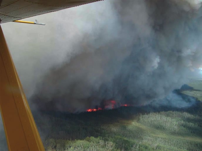
Fortunately, the next morning brought a nice breeze that pushed the smoke from the Sun Valley fires away from us. Those same winds, however, turned a small blaze to the west into the towering pyrocumulonimbus pictured on page 17. We could only get a glimpse of it, peaking over the ridge, but it was quite impressive. I was beginning to feel surrounded by fires and worried that the new one might top the ridge and fill our valley with smoke. I considered evacuating, but a charter pilot landing with the last load of the evening said it was 10-15 miles away and several ridge tops over. Our weekend would remain VFR.
Resources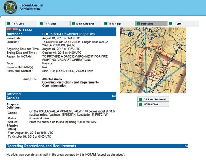
Coughing Stratus
It was the tail end of the fire season when I headed to an Idaho Aviation Association board meeting. Despite cooler temperatures and fall conditions, there was still the remnant of a small fire just east of my destination airport.
As I crossed the ridge to descend into the canyon, it looked like there was a solid layer of stratus clouds blocking our passage up river. It was, in fact, a layer of acrid smoke that started me coughing as we descended toward its edge. It was like standing in front of a campfire and taking deep breaths.
We stayed out of the thick of it, but visibility dropped as we passed through the layer still able to see the canyon bottom and sides. I was not happy about the reduced visibility and almost chose to abort the descent just as we broke out of the smoke and into the clear with the visibility beneath 10-plus miles.
Heat and Turbulence
My final smoke-related experience came on a return trip from Van Nuys, Calif., to Boise, Idaho. The route, which took me near Inyokern, Calif., is on the eastern side of the Sierras and subject to mountain wave. Terrain and the restricted airspace of China Lake leave very little choice in routing. You basically hug the mountains until you are clear of the China Lake NAWS restricted area.
As we headed north up the Owens Valley, we could see a plume of smoke, originating from the western side of the Sierras, topping the ridge and sloping down the eastern slope ahead of us. From a distance, it looked odd because the left side of the smoke plume was higher then the right side. It had a laminar look to it and didn’t appear to be moving. We could see above and below the plume, so it seemed innocuous, a very localized phenomenon. Not wanting to change altitudes and not expecting much impact, we stayed our course.
When we passed into the plume, all hell broke loose. It was extremely turbulent and after a few ups and downs we were gripped by a monster downdraft. I pitched up for a VY climb at full power and we were able to hold altitude loss to a minimum all the while getting smacked around by continued turbulence as we watched cylinder temps rise due to the climb, warmer air and slower airflow. At the same time, visibility dropped to three miles or less. I wasn’t expecting that.
We were halfway through it, and a 180-degree turn was going to subject us to more of the same, so we pressed through to the other side. On the other side of the plume, everything returned to normal, apart from our slightly bent nerves. I am not sure what the exact lesson learned was, but if I see a smoke cloud like that again, I will definitely consider an altitude change rather than going into the cough-inducing downdraft.
Avoidance Advised
If your flying has been confined to more-populated regions, you may never have encountered airborne smoke from a wildfire. The first time you do, from a distance, a smoke plume can appear all nice, fluffy and inviting—just another cloud. But up close and personal, smoke plumes contain violent updrafts, IMC conditions and even rock-hard terrain.
Avoiding airborne smoke should be an easy task, with the proper planning. Stay in visual conditions, but plan for IMC.

