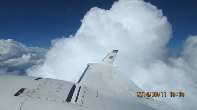
It’s a staple of instrument flying: the need to alter your route to avoid weather hazards. Often the obstacle in your path is a building cumulus cloud—a thunderstorm. The good news is that ATC is almost always willing and able to let you maneuver around clouds with extensive vertical development. All you have to do is ask (although sometimes we’ve seen ATC offer a different route in advance). Before you make the request, however, there are several things you need to consider to safely and successfully maneuver around the threat.

Deviating From What?
FAR 91.123 tells us pilots are permitted to deviate from an ATC clearance when “an amended clearance is obtained, an emergency exists, or the deviation is in response to a traffic alert and collision avoidance system resolution advisory.” Deviation around storms (or vertical clouds) does not constitute an emergency, nor (of course) is it the result of a collision warning. It is an amended clearance…a route and altitude you must follow while operating IFR. You’re deviating from your route, at least temporarily, but you are still on an instrument clearance. Unlike most amended clearances, however, you usually have to ask for deviations.
Most of the time, ATC is not going to initiate a revised clearance around weather. Sure, as time and their equipment permit, controllers will point out when precipitation returns are heavy along your route of flight. Unless you specifically ask for an amended clearance, however, ATC will permit you to fly into the teeth of a storm. In other words, it’s all up to you. You have to decide what’s safe and what you’re comfortable with. Further, you need to make this decision and determine how you plan to avoid the hazard before you get yourself into trouble.
Making The Request
There are two ways to ask for a deviation around storms. The first and most common way is to ask to deviate left or right (or east, west, north or south) of course. The exchange might go like this:
PILOT: “Center, 12345, request.”
ATC: “12345, say request.”
PILOT: “12345 requests deviation north for weather.”
ATC: “12345, deviation north of course approved. Advise when able to resume course.”
You are now free to fly around the north side of the weather you want to avoid. Once around it, reintercept your original route, usually by proceeding direct to your next fix. Tell ATC when you no longer need to deviate around weather; they need to know where you’re going next.
There are some shortfalls of this common deviation strategy. If there are other airplanes in the area, ATC may not be able to clear you for an unlimited block of airspace (in this case) to the north of your course. If you are near the edge of a controller’s sector, he or she may not be able to coordinate your deviation, given they do not know precisely where you may go. The next controller may not accept the deviation, and you may need a new deviation plan. Either way, ATC will have to watch you, and anyone else deviating around the storm, because you’re not on any specific route—their workload will increase significantly, and if a lot of airplanes are in the area, ATC may be reluctant to issue a simple “fly around it” clearance. And although I usually have at least two moving maps running in my cockpit, I still don’t like the feeling of just “flying around” on an IFR flight.
The second, less-common way to deviate is to ask for a specific amended clearance. Instead of asking to “deviate north,” request something like “direct INDIC intersection, direct Wichita, then as filed.” When ATC grants this type of deviation, the controller knows exactly where you’ll go. He/she may be better able to quickly grant your request and accommodate other pilots deviating around a cell. Lastly, this gives you an amended route to fly in the unlikely event you lose ATC communications.
I admit that, as a Southeast and Midwest thunderstorm-season flier, for years I asked for the “deviate north” type of amendment. I’ve found, however, that it works to everyone’s advantage for me to ask for a specific amended route when deviating around storms.
The Green Between
Dr. David Strahle, a radiologist, is known as “the father of datalink radar” thanks to his expertise on weather radar interpretation. He’s the extremely rare subject-matter authority who not only knows his stuff but also is a genuinely captivating speaker who makes it easy to understand the advanced topics he relates.
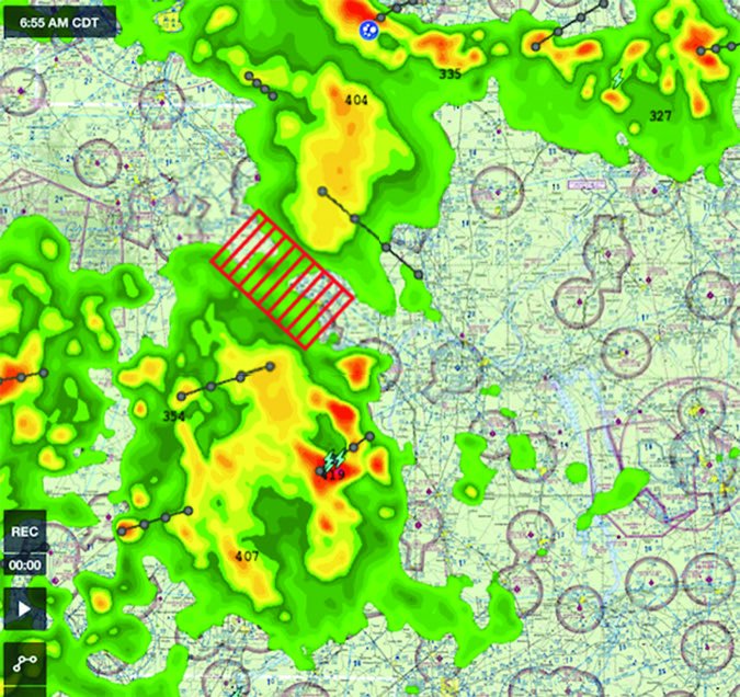
One point he stresses makes great sense when you think about it: It’s generally safe to fly through areas of light precipitation (green returns on most radar plots) if there is no moderate or greater precipitation associated with those clouds. However, he warns, if there is any moderate precipitation in the radar plot (generally yellow), you need to remain at least 10 miles away from even the light (green) returns surrounding the heavier precipitation. If there is heavy (often, but not always orange or red) or extreme (darker red, white or other) precipitation, remain at least 20 miles away from even the light (green) returns.
Why is this? Research shows that individual storm cells will “share” or “exchange” energy, creating massive areas of instability and turbulence between them that may be invisible to radar…and even to the eye. If there are moderate or greater returns in the storm complex, there’s the chance of extreme turbulence anywhere in it. Dr. Strahle warns that if a thunderstorm complex has enough energy to create yellow or red radar returns, it has the potential to create dangerous turbulence anywhere within or near the cloud.
So what exactly should you stay 20 miles away from? If there’s moderate, heavy or extreme precipitation (yellows, reds or worse) in the group of cells, it’s not safe to be anywhere in their precipitation footprint. Remaining 20 miles clear of that thunderstorm means staying 20 miles or more away from the outside edges of even the light-green radar returns.
Before You Deviate
Whichever type of deviation you request, you need to create your plan before you ask to change course. It’s not good enough to simply know you want to go around a storm. You need to knowhowyou’re going to avoid it.
First, gather data. The proliferation of weather uplinks makes this far easier than it used to be. That said, you need to know how to use the data you have. There are three basic hazards of thunderstorms and clouds with extensive vertical development: turbulence, hail and, to a much lesser extent, lightning strikes. How do you intend to avoid each of these hazards? Decide what route and altitude will you take—because no one will choose it for you.
Turbulence.The late centenarian pilot Captain Johnny Miller wrote prolifically about his storied career as an aviator “from Jennys to jets,” as he put it. John once wrote about an experience he had while crewing an Eastern Air Lines DC-8 in an area of strong thunderstorms. The airplane unexpectedly hit severe turbulence so intense that, even strapped in with two shoulder harnesses, he was flung upward and sideways, and hit his head on the upper sidewall hard enough that he was momentarily dazed. John speculated that in a light airplane, a pilot might hit the cabin sidewall or headliner with enough force to knock him/her unconscious…or perhaps even break the pilot’s neck. This, John suggests, might explain airplanes that lose control and crash when they stray too close to a thunderstorm but may not have actually penetrated the storm cloud. A pilot knocked unconscious by turbulence would explain many cases when an airplane went down when flying in the vicinity of thunderstorms.
Hail:Hailstones have been reported to have been encountered as far as 20 miles downwind of major cumulonimbus clouds. Generally, storms of this magnitude have well-developed anvil tops; one of the “classic weather text” warnings about thunderstorms is to avoid “severe” thunderstorm clouds by at least 20 miles and avoid flying beneath anvil clouds at any distance from the cloud boundary. “Regard as severe any thunderstorm,” the FAA tells us in Advisory Circular 00-06A,Aviation Weather, “with tops 35,000 feet or higher whether the top is visually sighted or determined by radar.” In my experience, that’s the vast majority of all thunderstorm cells. From a hazard-to-flight standpoint, we should avoid almost all storm clouds by at least 20 miles.
Lightning:A lightning strike is much less a threat than turbulence or hail. Modern aircraft and electronics are well grounded. If your airplane is struck, there may be some damage and you may lose some electronic equipment. But unlike turbulence or hail, it probably won’t threaten the airplane structurally. Avoid the cells by a wide margin and you should avoid the lightning hazard.
So the trick is to stay at least 20 miles away from the cells. But what are the cells? And how do you avoid them? It’s important to remember that uplinked weather radar data may not accurately reflect what you see out the windscreen. In 2012, the NTSB issued Safety Alert #017, advising that in-cockpit Nexrad has a latency issue of up to 20 minutes, the time since the Nexrad image was transmitted, not the time that the individual radar images were recorded, which will always be older.
Avoidance Strategies
Center air traffic control radars are optimized for aircraft detection, not weather returns, and they often cannot detect the light precipitation that may be the first indication of a mature-stage thunderstorm. The rate at which individual thunderstorms can build is so great that what appears to be a clear path can close in before an airplane can traverse the space between the cells. That may include your escape path, too.
Don’t get caught.Keep an easy avenue of escape open at all times. When deviating around cells, I’m constantly telling myself, “If it starts to close up or the turbulence reaches moderate, I will go XX,” where XX is left, right or back to where I came from. It sounds trite, but always leave yourself an out.
Stay visual if at all possible.Use the technology you have and whatever information you can glean from controllers, but remain in clear skies so you can visually maneuver around the buildups. Not everything hazardous will appear on radar. Storm cells can build rapidly, filling in the gaps before you can maneuver through (see the sidebar on the opposite page).
Fly high.Not only will flying as high as reasonable help you to better see and avoid many cells, it also supports remaining above the minimum vectoring altitude (MVA), an ATC requirement for any off-airways deviation. Climbing is no guarantee of avoidance success, but in my experience it makes it easier to determine whether you can continue or must turn around.
Go behind the cells.Plan your deviations to pass behind, on the downwind side of cells. This helps you avoid any hail threat. It puts you where the cells are blowing away from you, not coming at you.
Avoid the complex, not just the heavy precipitation.Any part of a storm cell is part of that cell’s greatest hazards. Avoid the entire storm complex, not just its heaviest returns. Go between cells only with great caution. (See the sidebar on page 17.)
Don’t try to deviate within large areas or multiple lines of storms.It’s far too likely you’ll find yourself caught with no way out. The classic texts also advise us to avoid trying to fly in areas with more than 60 percent coverage of thunderstorm cells, even if we have airborne weather radar. We need to heed the warnings of those who flew before us.
Escape sooner than you think you need to.Most deadly storm encounters start benignly and get progressively worse until the pilot either fails to execute his/her escape option—or has no options left. It’s enticing to keep going once you’ve committed to a deviation strategy. The trick is knowing that almost no decisions in life are irreversible, and you may be trying a deviation strategy, but you are never committed to seeing it through unless you’ve let yourself go too far. It’s time to exercise your escape option when you think you might need to deviate from your deviation.
Deviant Behavior
In-cockpit Nexrad data did not change the rules of aircraft design or the laws of aerodynamics. Airplanes are not more capable of penetrating areas of storms because the pilot can see recent history on an iPad or panel display, or even real-time onboard radar. What today’s technology does do, is to make it much easier to remain at least 20 miles from the edge of storm cells and buildups and to see beyond the next line of clouds to make more long-range plans.
If you’re coming up on an individual cell, a line or an area of storms, and you determine it’s possible to safely circumnavigate not only the clouds themselves but the entire threat areas, devise your plan, tell ATC what you’d like to do and continually reevaluate your plan until the hazards are far behind you.
Life Cycle of a Storm
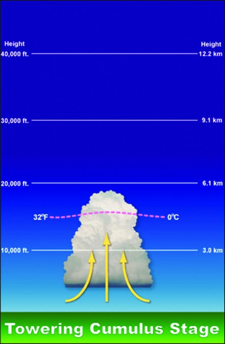
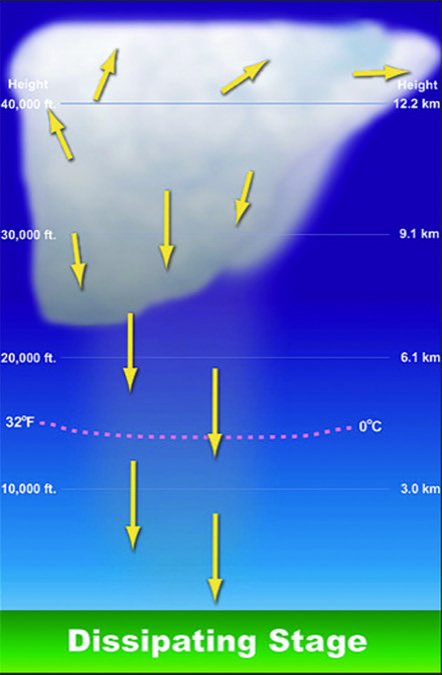
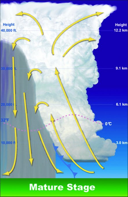
In a thunderstorm’s developing stage, vertical air velocities of 2000 fpm can occur. The mature stage, defined as when precipitation begins to fall—and therefore when the first echoes appear on radar—has rising and falling air currents on the order of 5000 to 6000 fpm. In the dissipating stage, air descends at 6000 fpm or more. One of a thunderstorm’s greatest hazards is encountering the wind shear between still air and rapidly rising and falling columns of air.
An individual cell in an area of thunderstorms can complete its entire life cycle in about 30 minutes from beginning to end. Many take much longer. Areas or lines of storms may appear static, but within them individual cells are forming, thriving and dying all the time. Critical to a pilot’s interpretation of Nexrad or airborne radar is that, by definition, dangerous turbulence occurs before rain begins and therefore before the cell may appear on radar.
Playing TAPS
Just as we should avoid flying within 20 miles of a thunderstorm, we should slow the airplane to its turbulent air penetration speed (TAPS) to avoid overstressing the airframe. In most personal airplanes, TAPS is usually the same as the design maneuvering speed, or VA, below which the wing will attain its critical angle of attack and stall before it exceeds the airplane’s positive load limit, reducing its loading and helping prevent catastrophic damage.
VAis defined solely at the airplane’s maximum gross takeoff weight, which by definition must be reduced when encountering a storm. It’s themaximumspeed we should use in turbulence, an unofficial new VNEor “barber-pole” speed, while the target airspeed must be a good bit lower, so airspeed excursions are below it. Second, you must slow to TAPS before you enter turbulence: You don’t get a free bump before you slow down, because the airplane will exceed its structural limit in that first bump if you’re not already below VA.
Tom Turner is a CFII-MEI who frequently writes and lectures on aviation safety.

