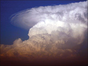
As anyone who’s paid attention to Central U.S. weather the last few months knows, it’s been a particularly violent spring across “Tornado Alley.” Midwest storms made national news and reintroduced repeat targets—such as Moore, Okla. Well ahead of the storms and far in front of the inevitable miles of destruction images, Americans coast to coast shared ringside seats of the progressing destruction thanks to the coverage of storm chasers who shared real time some of the clearest videos and still images ever made of in-progress tornadoes. Most images came from a large contingent of ground-pounders but, more than ever before, much of the resulting imagery was captured through the efforts of people aboard aerial platforms, whether helicopter or fixed-wing.

288
The existence of so much fine imagery makes denying the possibility of success wholly hollow. But this kind of flying begs for the standard “don’t try this at home” disclaimer. Obviously, these pilots/photographer are succeeding, safely. But not without preparation and practice. The good news is their successes are instructive for those of us watching from a safe location. The better news is we can use their experience to learn how to stay out of extreme weather.
Obvious Risks, and Not
There’s a reason so many of the tornado and storm shots we’ve reviewed this spring and summer offer such striking, unobstructed views of the tornadoes. The chaser, air- or ground-borne, intercepts the storm after the wall cloud, the rain, hail and massive winds have passed. From the back side, some light rain may fall, but the bulk of it has already passed. In the bargain, the storm’s size, speed and location are well-known by this point. Immediately, we can derive from the storm-chaser’s experience something useful: the benefits of being behind the storm and not in its path.
For example, being behind the storm allows us to fly in apparent clear air on a track parallel to the it, or at least parallel to it until it changes course. Also, we can avoid the worst of the storm’s hail and turbulence by circling around to the backside. This basic technique applies to garden-variety thunderstorms as well as super cells and tornadoes: How often have you sat out a violent storm on the ground, only to be pleasantly surprised by the calm weather it left behind?
So it should go without saying, but we’ll say it anyway: Under no circumstances should a pilot consider penetrating such a storm. When considering a tornado, you could get through the barely penetrable outer veil of the storm’s core only to find yourself spinner-to-vortex with a twister. And that turbulence can be sufficient to trash a truck, tear apart an airplane and destroy a pilot’s control of the aircraft—even after you’ve followed all the guidelines to keep yourself safe.
Best Practices
Of course, general aviation aircraft and their occupants survive inclement weather encounters on a regular basis. They do so by staying out of the storm: The FAA’s distance recommendations cover what you need to know and staying clear of clouds keeps you safe. And a storm’s existence never should come as a surprise since the conditions announced in Airmets and Sigmets are worth noting on an ongoing basis. Whether you seek to avoid or encounter these alerts, they provide the details and location needed to execute either goal.
But even the FAA’s recommendations on dealing with violent weather need some interpretation. For example, the agency’s Advisory Circular Aviation Weather (For Pilots and Flight Operations Personnel), AC 00-6A, advises the following: “Avoid the most intense echoes by 20 miles; that is, echoes should be separated by at least 40 miles before you fly between them. As echoes decrease in intensity, you can reduce the distance by which you void them.”
While this advice was generated well before data-linked Nexrad weather displays became available in the average cockpit and is based on reported storm locations derived from older technology, even this bold statement has some wide gaps. For instance, are we talking statute or nautical miles? (Of course, if you have to ask, you’re missing the point.) Also, how are we to know an echo’s intensity? Where in relation to the storm? Twenty miles from the front side you can see? Twenty from the center? Or from some other identifiable realm of a mostly obscured maelstrom? Use some sound judgment when answering these questions: Storm-chasers both airborne and land-based report they’ve experienced metal-damaging hail encounters tens of miles away from storms and 20 miles or so from what’s conventionally considered the outer limits of hail.

288
While the damage potential of hail is legendary, that potential pales when compared to the threat of debris from a violent storm. Debris as a threat varies in size and potential with the jetsam sucked aloft after a twister explodes a structure. Destructive debris often travels miles high and dozens of miles far—in all directions, upwind, downwind. This can include remnants of structures destroyed by the storm, like 2x4s, whole and partial pieces of plywood, all kinds of metal and even pieces of furniture and assorted household appliances. (An acquaintance whose home took a direct tornado hit earlier this year recovered valuables from more than 30 miles away; among them was a professional-size 35-mm film camera…with lens.)
Encounter this stuff aloft and it won’t shatter on impact as do most hailstones. And there’s never been a bird strike that could match the damage of colliding with a small piece of timber tossed aloft.
Approaching Storms
All those tornado shots we’ve seen came from people who got closer than the FAA recommends, even though they generally approached the twisters by staying in the clear. For the ground-chasing crews, that often means penetrating the so-called “hail veil” and rain bands frequently preceding the clearer air where tornadoes generally form.
Aircraft pilots—this writer included—have penetrated weather equal to the savagery of tornado-generating skies—and survived, if not also humbled. The key differences here are as clear as on the storm’s backside. In one instance, you stay where you can see what’s happening; in another, you effectively render yourself blind until you penetrate the back wall, where the twisters form. Popping out from in the blind is not conducive to tornado avoidance. On the contrary: Staying out of the clouds is the only way to keep clear when the twister forms and starts its own path of destruction.
Always Have An Exit
A pilot-rated politician once confided to me that one of his self-preservation mechanisms when out in public was to always—always—plot your escape route to safety. “Flying home every weekend, I employ the same strategy for dealing with weather: radar, eyeball, crystal ball—none of them can assure you of what’s on the other side of the black, so always preserve an escape route.”
Storm chasers and storm photographers try to follow the same philosophy. And it’s here that storm chasing from aircraft offers one advantage to offset the obvious vulnerabilities: the infinite heading choices available to escape an approaching storm or tornado, whether resulting from the storm changing direction or your own bad judgment.

288
How to implement such advice in your aircraft operations? Simple: The 180-degree turn is the maneuver of choice. Whatever heading you flew to get there, the reciprocal should get you out again. For some additional tips, see the sidebar at left.
Judging Distances
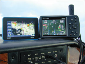
How to establish that 20-mile no-transgression zone around a thunderstorm? Many tools can help here, if you’re open to adding to the loose missiles turbulence can inflict on you and the cockpit. Rangefinders used for hunting might help, but landmarks matched against Nexrad displays or moving maps may be the most expedient and least risky. My favorite has long been the moving map display scaled to a relatively small maximum range—say, 10 miles—and then comparing the landmarks to the view out the windows. This requires some equipment we may not have aboard, but we probably have no business where we are without such gadgetry.
And this again begs the question: What are you doing here in the first place? Another way to put it is this: If you have to ask yourself if you’re too close to a violent storm, you probably are. Come up with a Plan B or C and implement it.
Storm System Types
Let’s apply two simple rules when trying to gauge the dangers of thunderstorms. First, and generally speaking, the most violent weather is encountered in advance of a fast-moving cold front generating steady-state thunderstorms. The type of storm we’re thinking about here isn’t the basic kind with the three stages we were taught early in our training—building, mature and dissipating. Instead, these storms form, build and start moving.
Their motion basically means they’re immune to dissipating until the associated weather system—a front, a trough or converging wind—dies out or moves away from terrain influencing its behavior. Such a storm system can extend hundreds of miles, making it impossible to get on the backside or find a hole through it to clear air.
The second rule is that it really doesn’t matter if the storm is associated with a front or is of the slightly more benign air-mass variety, such as those populating Florida and other southern states this time of year: It’s still a dangerous, violent place to be. But that doesn’t mean you don’t have some advantages.
If the storms are moving along with a cold front, the various weather products you should obtain and understand during a pre-flight briefing will provide a good idea of where they are, where they’re going and when they might pass your location, or the location at which you plan to be. The best thing to do is wait it out, either by landing and securing the airplane before it gets to you, or delaying your takeoff until it passes. Again, Nexrad can be your best friend, and you can while away the time it takes for the storms to pass by clicking refresh on the computer in the FBO’s pilot lounge or betting the line guy the exact time blue sky will be seen.
Meanwhile, air-mass thunderstorms impose a different good news/bad news equation. As mentioned above, they’re usually less violent than the fast-movers. The bad news, of course, is they’re not fast-movers. If you’re trying to get into an airport and there’s an air mass thunderstorm sitting on top of it, it easily could stay there for a couple of hours. Your best choice may be to divert to a nearby facility and wait it out. The other good news about air-mass storms? Since they’re not moving, they’re easy to outrun. Use that capability to your advantage.
Don’t Try This At Home
Whether airborne or ground-pounding, the storm-chasers who bring back images detailing the beauty and horror of extreme weather do the rest of us a great service and bestow a learning opportunity: They plan their encounters based on skills and experience most of us don’t have (and don’t want!), which should reinforce in our minds that we’re mere amateurs when it comes to this kind of flying. The basic rules they employ—avoid a storm’s front, stay visual, keep your distance and always have an exit in mind—are the same ones we should use when the mission demands we deal with extreme weather.
Dave Higdon is a professional aviation writer/photographer with several thousand hours of flight time.


