A friend told me about his airline’s final takeoff briefing, the acronym for which is WARTS: Wind and Weather, Aborts and Abnormals, Runway and Route, Terrain and Specials. It’s a useful guide to making sure everything is ready for departure, and I use it regularly, even in the Cessna 150 I sometimes fly. (It’s cheap and fun!)
In the 150, there isn’t too much to say about terrain. I only fly it VFR, and the airport I fly it from is surrounded by farmland. Given some of the terrain I’ve flown over in the past, that seems like a luxury. But it’s probably a good thing in the 150.
Rifle, Colorado
Imagining flying into and out of unusual airports isn’t just hangar flying: it’s effective recurrent training. I’ll concentrate on procedures for flying under FAR 135, while those flying non-commercial under FAR 91 are free to invent clever methods of self-destruction (see the sidebar on page 12). It’s better to fly the departure procedures, instead. Remember to use current charts and performance data if you try it for real.
Consider the Rifle Garfield County Airport in Rifle, Colorado (KRIL), with a field elevation of 5537 feet msl. That can be daunting, but it gets better (or worse, depending): Rifle lies in a sectional chart quadrant whose maximum elevation figure is 11,300 feet, and the MEF in the next quadrant to the south is 11,700 feet. Terrain is relatively flat to the west, but rises to the east, on the backside of the Front Range.
Runway 08-26 at KRIL is uphill to the east, so one would only depart Runway 08 with a strong easterly wind. Most of the airplanes I’ve flown into there allow a maximum tailwind component of 10 knots, so assume 10 knots of wind out of the east. You have to choose between east and west departures. Each has advantages and disadvantages.
For an east departure, the wind helps because the reduced groundspeed means a steeper climb gradient, but the runway gradient means a longer takeoff roll. Departing Runway 26 with a tailwind, although legal in this case, also means a longer takeoff roll and increased groundspeed, hence a shallower climb.
There are two east departures, which follow relatively low terrain. The EDUKY FIVE is an extended right downwind departure joining a Victor airway headed west. The UYRIG FIVE is more of a straight out, headed East. There’s also a visual climb over airport (VCOA) departure procedure that involves climbing in the hold over Rifle VOR.
That’s the horizontal situation. But every departure here requires flight toward higher terrain, which means climbing steeply. Not wrap a white scarf around your neck and yank back on the stick steep, though. The charts state how steep.
Takeoff minimums for Runway 08 are standard if one can climb 400 feet for each nautical mile forward. The charted procedures provide a little relief. The EDUKY departure requires 396 feet/nm, while the UYRIG requires 335.
But that’s nothing. The takeoff minimums procedure for Runway 22 at Lander, Wyoming’s Hunt Field (KLND), requires 495 feet/nm until reaching 8500 feet msl. At 90 knots groundspeed, 400 feet/nm means climbing at 600 fpm. “My Bonanza can do that,” you think. Good luck with that. Depart on a moonless night and you might not feel like it’s enough. The thing is, you may have to climb at 600 fpm or greater well into the teens. Can your normally aspirated piston single do that?
The Math
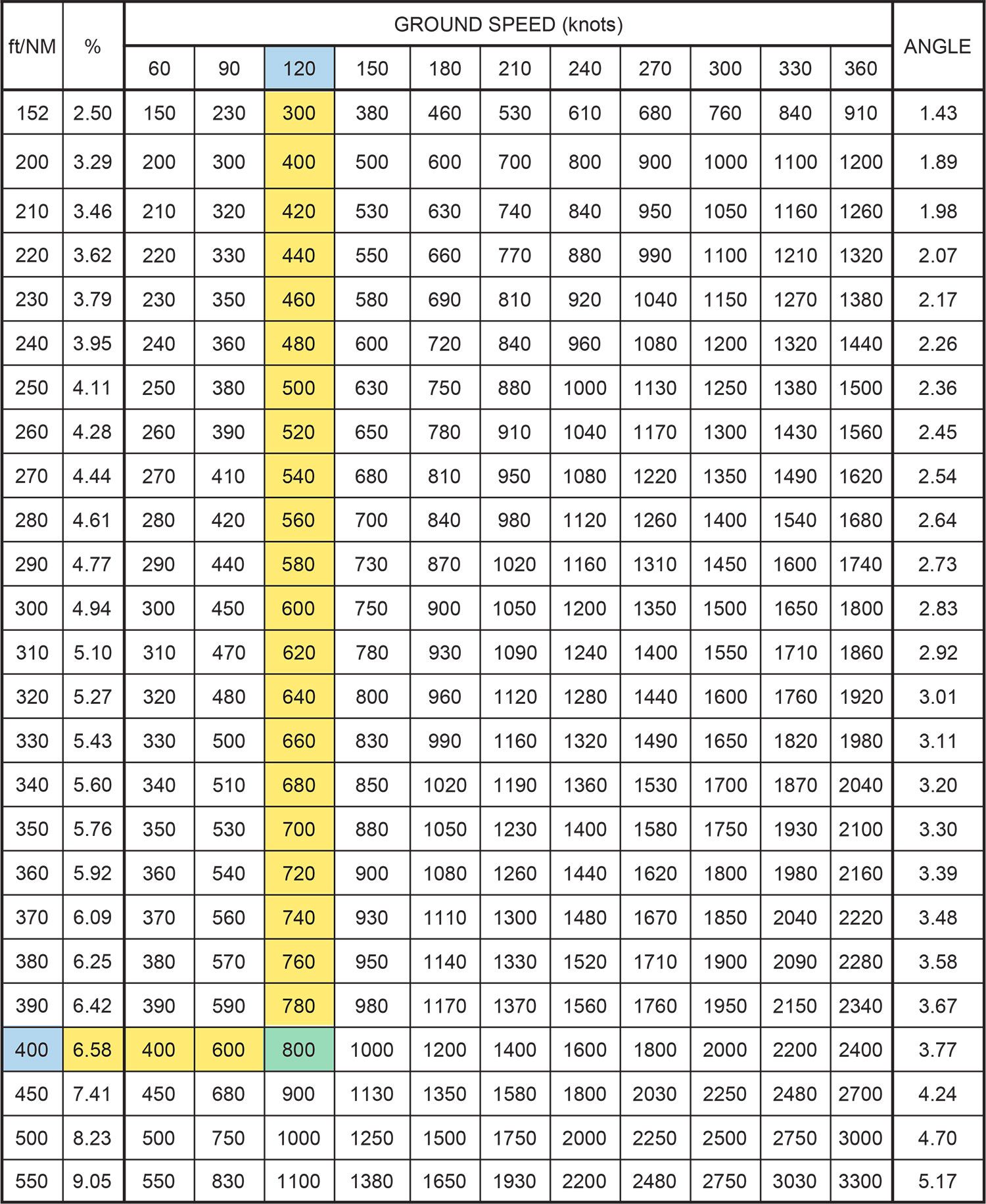
Airplanes don’t have any “how steeply are we climbing?” display, so pilots have to use vertical speed. The conversion is in the Rate of Climb/Descent Table at the back of what ForeFlight calls the Digital Terminal Procedures Supplemental. (As a reminder, this document also has the inoperative components table, describing adjustments to approach minimums when something on the airfield, like touchdown zone lighting, is broken.)
To use the table, pick the row for your desired climb gradient, and move across to the column for ground speed. The trickiest part of using the table is remembering to use ground speed, not indicated airspeed. The next trickiest part is remembering to calculate performance at the top of the climb, which will be lower than performance at the beginning.
For example, imagine a climb speed of 90 kias. That can translate to a true airspeed of 110 knots at 11,000 feet msl, the top of the climb. There are online calculators for this, but the rule of thumb that true airspeed increases two percent every 1000 feet of altitude works pretty well. In this case, at 11,000 feet, add 22 percent to 90, which rounds to 110 knots.
This calculation can make a big difference. While at 90 knots, the required climb rate for 400 feet/nm is 600 fpm, the required climb rate at 110 knots is about 740 fpm (rounded up a little). The Cessna 150, near its service ceiling, might get 100 fpm there, one-eighth of what’s required. Add in the 10-knot tailwind component and the groundspeed is 120 knots, requiring 800 fpm of climb. Again, good luck with that.
The time, fuel and distance-to-climb chart in the POH can also tell you the net climb gradient: Divide the climb needed in feet by the distance the table gives you. With an IO-520-powered Beech A36 Bonanza at gross on a standard day, a climb from 5650 feet msl to 11,500 would take 18 nm, netting 325 feet/nm. That’s not even close to good enough.
Loss Of Performance
Sometimes people think doing math will kill them. Sometimes not doing math can have the same effect. So go back to focusing on aircraft—you know, those things that have engine failures?
Engine failure always leads to a loss of performance. A big loss of performance, even in a twin. Take the Piper Apache, for example. According to the POH, at 2000 feet msl and maximum gross weight, the 150-horsepower version (PA-23-150) will climb at about 1000 fpm with both engines operating. At 10,000 feet msl, it will climb at 400 fpm, so it’s already ineligible for an IFR departure out of Rifle under FAR 135. The thing is, it can barely make the climb gradient when nearly empty.
Take away one engine and the 2000-foot msl climb performance becomes less than 100 fpm. Above 6000 feet msl, the climb rate is actually negative. The only solution may be to take off at a lower weight. As my first instructor said, the best way to get a big load off of a difficult strip is take out a lot of small loads.
Risk Management
Airports like Rifle can raise a lot of risk management questions. The first consideration is whether the airplane can fly the procedure under ideal conditions. If not, will reducing the weight help? Or colder air? Right off the bat, an option may be to wait for good VFR weather conditions.
One way to reduce weight is to stop well short of the destination. Grand Junction, Colorado (KGJT), is less than 50 miles from Rifle and has easier climb requirements. The fuel you landed with in Rifle may be enough to get you to Grand Junction with reserves.
If that doesn’t work, and the rules you fly under permit it, then you can start evaluating the risks. How likely is an engine failure? There may not be a time-fuel-distance table for the engine failure situation. One strategy is to get maximum performance early in the climb to keep the airplane above the climb profile, leaving some cushion for an engine failure. That requires perfect configuration and near-perfect pilot performance.
How likely is there to be icing? Icing always reduces aircraft performance. If the aircraft is certified for flight into icing conditions, one may still choose to go, but be aware of the increased risk.
Tools
Lately, I have been pleased to hear more pilots talking about the FAA’s PAVE risk management tool. The acronym comes from Pilot, Aircraft, enVironment, External pressure. In the case of places like Rifle, the interaction between aircraft and environment raises the most questions. The answers to these questions come in the form of performance data in your POH/AFM and navigational charts.
External pressure is harder to quantify. We’ve all felt it, and we’ve all probably got a mixed record of responding to it. Be aware that it is there.
In the U.S., non-commercial flights (i.e., those operating under FAR Part 91) are not subject to takeoff minimums, while commercial flights under FAR Parts 121, 125, 129 or 135 have to have the visibility required by FAR 91.175. There is no minimum ceiling.
 The minimum visibility depends on how many engines are available. For one or two engines, the requirement is one mile, unless charted otherwise. For three or more engines, the requirement is ½ mile. Three-engine airplanes are becoming more and more rare. There are a few MD-11s flying freight, and some DC-10s doing wildfire suppression, but when was the last time you saw a Boeing 727 or a Britten-Norman Trislander in the wild?
What happens if something goes wrong in low visibility? That’s another risk management question.
One problem is that takeoff often is legal/possible even if the weather is below landing minimums. If something goes wrong shortly after takeoff, it’s unlikely returning to the airport is a real option. In this case, the ceiling matters. A 100-foot ceiling with two miles of visibility probably means a missed approach.
That’s why FAR Part 135 requires a takeoff alternate when departing in weather below landing minimums. That alternate has to be within one hour’s flying time.