By Joseph E. (Jeb) Burnside
We all have so-called personal rules we use to help us make decisions when everyday challenges arise. In aviation, they are sometimes called personal minimums and are used to help us decide whether this mornings low visibility and cloud cover-even if legal VFR-will prevent us from getting that $100 hamburger.
Having flown my share of low-powered fixed-gear airplanes on long-distance flights, Ive developed a few such rules, most of them as a result of getting myself into one situation or another. For example, I dont care what the legal alternate might be after a long IFR flight; Ill file legally but I really care about the weather at the nearest ILS and how tired I might be when I get there. I place less emphasis on an airplanes maximum demonstrated crosswind capability than I do the direction of the wind, the runways orientation and its physical dimensions.

Another rule I have, before doing something in an airplane, is to think about how the NTSBs accident report might read if I screw up something.Often, that one by itself helps keep me out of trouble.
As another example, I know only enough about mountain flying to be dangerous and, after getting myself and a 160-hp Skyhawk into a mountain wave downwind of the North Carolina mountains several years ago, make it a rule to avoid using any airplane with less than 180 hp for a serious cross-country flight.
That rule served me well a couple of years ago when I helped a friend ferry her 180-hp Skyhawk from Virginia to its new home in Las Vegas. Waking up one morning in Phoenix to find the winds aloft along our route to be greater than the Skyhawks stalling speed, I opted to keep the airplane tied down and spend another day in Arizona. While Ill never know how easy, hard or dangerous the flight might have been the day of 50-knot winds, I do know the following day was smooth and delightful. Recently, while bouncing my way into Scottsdale through winds of substantially less velocity, I was reminded of that decisions wisdom.
Mountainous terrain isnt found just in the western U.S.-everythings relative, and there are some sizeable hills east of the Mississippi River, also. In addition to influencing a lot of the eastern seaboards weather from time to time, the Appalachians, the Catskills and other bumps in the road can make our flying dangerous or merely unpleasant. As we shall see, any time there are mountains along our flight path, its a good idea to fully inform ourselves of the flight conditions they can generate.
Background
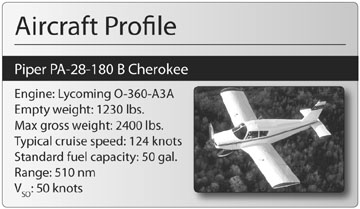
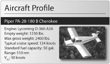
On November 21, 2003, at about 2100 Pacific time, a Piper PA-28-180 collided with mountainous terrain nine miles east of Big Bear City Airport, Calif. The airplane was destroyed and both aboard-a 2600-hour Commercial pilot and the passenger-were fatally injured. The flight originated at Palm Springs, Calif., approximately 30 minutes earlier.
The two men were participating in a Civil Air Patrol (CAP) search and rescue training exercise being held at Palm Springs that weekend. The crew arrived about 1730 and attended a classroom training session. Shortly, attendees were told high winds were expected the following day and flying operations might be cancelled. The aircrew decided to return to their home base at Big Bear Airport instead of staying the night. The two men never returned to Palm Springs the next day and the CAP notified the FAA of a missing airplane. The wreckage was found on the northwest slope of Tip Top Mountain, at 6900 feet msl. The ridge line directly above the wreckage was at 6970 feet; the highest points to either side were about 7200 feet.
All major aircraft components were found in the debris field, although impact and fire damage was extensive. Although the engine also was severely damaged, no pre-impact discrepancies were noted.
Two radar plots associated with the accident aircraft were generated from the collected radar data. The track plot for the last 13.5 minutes of flight shows the airplane approaching the mountain ridge at between 10,000 and 10,300 feet on a steady westerly course. The profile plot shows a steady descent of the airplane from 10,300 feet to 8000 feet during the last four minutes of flight. Throughout the last two minutes of flight the airplane descended from 8900 feet to 8000 feet, at which point radar contact was lost.
Investigation
No record was found of a weather briefing given to the pilot either under his name or the airplanes registration number for either of the two flights that day.
The NTSB performed a full meteorological study surrounding the day, time and location of the accident. The surface analysis chart showed an approximate 12-mb change in pressure across southern California, resulting in strong westerly surface winds. Observations west of the accident site included calm winds at the surface with fog or mist, broken cloud cover and temperature-dew point spreads of one degree F. Other coastal locations across southern California indicated westerly winds with overcast skies. The accident site was on the front side of an upper level trough with westerly winds. Airmet Tango was active over portions of California, Nevada, Utah, Colorado, Arizona and New Mexico, and warned of occasional moderate turbulence below 16,000 feet due to moderate-to-strong winds over rough terrain.
Numerous pilot reports were recorded over southern California surrounding the time of the accident, and reported turbulence and downdrafts of around 500 fpm.
The NTSBs report notes performance information available in the Piper Cherokee B Owners Handbook shows that at a max gross weight of 2400 pounds and between 8000 and 10,000 feet density altitude, the airplane had a maximum climb performance of 360 to 410 feet per minute.
Probable Cause
The NTSB determined the probable cause(s) of this accident to include the pilots inadequate preflight planning and intentional flight into known adverse weather conditions. Contributing to this accident was the fact that it was a dark night with no moon illumination.
Pilots flying over a familiar route, even at night, often neglect to obtain a weather briefing if the weather is good at their departure point. In this instance, Palm Springs was windy, with forecast winds at 10 knots and gusts to 20; an amended forecast included gusts to 25 knots. Additional information from the areas weather forecasts included the possibility of mountain wave action (see the sidebar above) well in excess of the airplanes climb capability.
Time and time again, we see accident reports where there was no record of a pre-flight weather briefing. We cant know if the simple act of requesting a weather briefing would have given this pilot information on the forecast mountain waves. However, if the pilot at least had requested a formal weather briefing, that information would have found its way into the NTSBs report.How will the NTSBs report on your accident read?
Also With This Article
“Predicting Mountain Waves”


