One of the most misunderstood pieces of equipment in the modern cockpit is airborne weather radar. For most of us, its a luxury we cant afford: either sferic devices (Stormscope/Strikefinder) and/or datalinked Nexrad images serve as a pilots third-best tool for avoiding thunderstorms. We say “third-best” because the best thing ever used for this purpose remains the Mk. I, Mod. I human eyeball. The trick, of course, is the eyeball only can be used in visual conditions. By happy coincidence, thats the best place to be when contemplating flight in an area of thunderstorms. 288 But visual circumnavigation of convective activity isnt always possible. Instead-and if youve got the room in the nose or a wing-mounted radome-an airborne radar installation remains your second-best solution. Yes, Nexrad is widely available and much less expensive, but it doesnt do the same job as the airborne equipment. Despite its occasional use otherwise (by us and others), Nexrads best role is as a strategic tool-for identifying and verifying the big picture-not for the tactical penetration of a squall line. Unfortunately, few pilots ever get quality training in using airborne weather radar. This article wont fix that, but we will show you what you dont know.
What Radar Cant Do
First, lets agree there are four weather phenomena that can damage an aircraft, and none of them can be directly detected by radar, including Nexrad, or by weather satellites using infrared or radar detection methods. They are in-flight icing, turbulence, (including wind shear and microbursts), hail and lightning.

288
Rain is generally harmless, but there have been occasions where the sheer volume of water ingested into an engine has caused a flameout. (See also, “Why Rain Is A Pain,” February 2010.) Turbulence, however, remains the principal hazard to aircraft. Meanwhile, hail and lightning both have been blamed for downing an otherwise-capable airplane, but neither can be detected by radar. Yes, hail can appear on radar, but will appear as rain, perhaps as extremely heavy rain. Even most sferic devices contain circuitry eliminating nearby lightning strikes from their displays. We know this from experience.
But a thunderstorms turbulence can cause major damage and has been known to tear apart large aircraft. Even though we cant directly identify turbulence, its presence can be inferred by locating water droplets (rain), which, luckily, is readily detected by radar. Fortunately, theres a high correlation between the volume of liquid water and the presence of hazardous phenomena like turbulence and hail. Thus, radar can be used indirectly to infer the presence of those hazards. Of course, since these phenomena occur within and around thunderstorms, the real challenge here is thunderstorm avoidance.
Detection
The first thing to remember about weather radar is this: It can see water best in its liquid form (not clouds, not water vapor, not ice crystals and not small, perfectly dry hail.) It can see rain, wet snow, wet hail. It can also see dry hail when its diameter is about 80 percent (or more) of the wavelength in use. As almost all current weather radars use a three-centimeter wavelength, that means one inch or more in diameter. Even then, reflectivity is fairly weak. This is because radar reflections are created by microscopic electrical currents which flow in the target. If the target is non-conductive-like pure, uncontaminated ice-there will be no reflection.
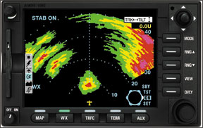
The severity of the aeronautical hazard is well correlated with the amount of liquid water present in a thunderstorm, and the strength of the radar-returned signal is proportional to the amount of liquid water. So, its convenient to make arrangements to show intensity on the radar display. Early weather radars had monochrome displays, and as the human eye is very bad at observing light intensity, a signal level was set where a black hole was punched in targets to indicate the returned signal, and thus water content, was above a certain preset level. This level was/is 12.5 mm/hour rainfall rate, and equates to the red level in current color radar displays.
In the absence of dry hail, it is generally agreed that green is harmless, yellow might give you a shake up, and red will be serious. The usefulness of the magenta level is debatable: I have seen proposals that many more colors could be used, but that makes the contour lines difficult to see.
Thunderstorm Flavors
Thunderstorms come in two main types, stratiform and convective. Stratiform storms generally do not tower to great heights, mainly lurking around the freezing level. As they often contain very large wet snowflakes, they are highly reflective and can give very alarming radar signatures, often into the magentas. However they are generally not very turbulent. Of course, anything is possible at least on statistically improbable occasions. My advice? Dont guess: Treat every red or magenta image as dangerous.
Convective thunderstorms, on the other hand, are always dangerous. These are the guys towering up to the tropopause (about 60,000 feet) and a little above, with an “anvil” trailing downwind. Their cores contain vertical velocities of up to 200 knots, and similar winds can be expected around the periphery. This severe windshear can literally tear an aircraft apart, and has done so on more than one occasion. The zone where these two vertical winds rub against each other will be filled with eddies, which themselves are well worth avoiding.
One of the “features” of a convective thunderstorm is that any large raindrops are shredded into smaller ones, so that the radar reflectivity is reduced. Thus, magenta level paints are unusual in serious convectives.
Once a thunderstorm has been identified by radar, a decision must be made as to how best to avoid it. Penetration should not be an option. A quick rule of thumb is to place 20 miles of clear air between you and the thunderstorm, and if possible, pass it on the upwind side. Remember to check on longer ranges to ensure you are not deviating into additional, unseen weather areas.
Clear air turbulence is a constant but low-probability hazard and cannot be detected by radar. However, turbulence can be detected when it is part of a precipitation event. Many modern radars feature a “turbulence” mode, which extracts turbulence data from ordinary radar signal returns. This mode cannot extract turbulence data from areas with little or no radar returns.
Attenuation Tech
Attenuation is the opposite of “penetration.” When a radar attempts to look through a storm to see a storm behind it, some of the radar energy is lost in its transit through the near storm, and some of the distant storms reflected signal is lost in its transit back through the near storm. In severe cases, the radar energy cannot even get to the back of the near storm, so that a characteristic “crescent” shaped target is displayed. Such crescent-shaped targets should be interpreted as a dire warning.
The crash of a Southern Airways DC-9 on April 4, 1977, outside Atlanta, Ga., was a consequence of poor radar management and attenuation. En route from Huntsville, Ala., to Atlanta, the aircraft flew toward a huge weather complex, with enormous amounts of wet hail. The weather target seen by the crew was a crescent, but because the radar was selected to a fairly short range, it displayed only a portion of the massive storm the airplane was about to enter. The flight path selected appeared to pass through the narrowest part of the weather target into clear air, but this was in fact through the densest area with maximum attenuation, and was consequently the most dangerous part. The aircraft encountered destructive hail that wrecked both engines and shattered the windshield. A deadstick landing to a two-lane road ensued, killing 62 and injuring 22.
A very similar accident occurred just three years later, in Valley, Neb. A Swearingen Metro II regional turboprop operated as a scheduled Air Wisconsin flight attempted to maneuver through thunderstorms. The crew had selected an intermediate radar range-probably 50 nm-and was flying in fairly constant rain. This generated a green level target extending approximately 11 miles from in front of the aircraft. The crew presumed the area beyond the target was clear air. Unfortunately, the intervening rain was dense enough to render the radar useless beyond 11 miles. The developing situation was monitored and later reported by one of the two surviving passengers.
The weather radar engineering community uses the terms “avoidance” and “penetration” to describe a radars ability to “see” light precipitation and to “see” through existing precipitation to the next storm behind. The choice of working wavelength/frequency for a weather radar has a severe impact on avoidance and penetration performance. Shorter wavelengths are good for avoidance, but have poor penetration capability. Consequently, attenuation is severe. Longer wavelengths have less weather sensitivity, but penetrate weather well to see the weather behind the weather. Three wavelengths/frequencies are assigned for airborne use, but most if not all radars currently on the market employ the “X” band as a good compromise between avoidance and penetration (attenuation).
Antenna size is another factor crucial to radar performance. Some people think a small antenna is like a small watch…it has all the functionality of its larger cousin, just packed into a smaller package. Sadly, this isnt true, because although the antenna is miniaturized, the radar wavelength is not.
A large antenna bequeaths two advantages: more gain (sensitivity) to “see” weaker targets further away, and a narrower beam resulting in greater detail in targets. As the same antenna is used twice (to transmit and to receive), the gain advantage of a larger antenna is doubled. Installations in smaller aircraft, including light and medium twins, as well as singles, are offered with 10-inch antennas, which are fairly useless, although probably a little better than nothing in the hands of a knowledgeable pilot.
In my opinion, a 12-inch flat-plate antenna is about the smallest useful size. Id want to see at least 15 inches in a parabolic antenna.
Looking Ahead
Airborne weather radars proper use isnt nearly as simple as many other gadgets in our panels. Failing to understand its limitations while depending on it for accurate information on which to make tactical decisions can have catastrophic consequences.
If you fly a radar-equipped airplane, the foregoing shouldnt be considered all there is to know about how to use the system. Instead, it should be used as the foundation for additional training and study. Many types of training are available these days, from study-at-home DVDs to classroom-style seminars. Anyone who depends on airborne radar should regularly seek out this kind of training.


